Detail GPS MAP 76 CSX
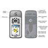
Keterangan: Navigate the Great Outdoors Find your way through the wilderness with the GPSMAP 76CSx' s high-sensitivity GPS receiver, which acquires satellite signals quickly and tracks your location in challenging conditions, such as heavy tree cover or deep canyons. You can use the built-in electronic compass to view bearing information even while you' re standing still, and the barometric altimeter tracks changes in pressure to pinpoint your precise altitude. You can even use the altimeter to plot barometric or ambient pressure over time, which can help you keep an eye on changing weather conditions. The 76CSx' s bright, color TFT display makes it easy to distinguish details on the screen in any kind of lighting. And, like the rest of the 76-series, 76CSx is IPX7 waterproof and even floats in water. Expand Your Memory Storing data is easier than ever with the 76CSx' s removable microSD card. This included blank card stores up to 128 megabytes ( MB) of optional maps or other data. The card slot is located inside the waterproof battery compartment, so you don' t have to worry about getting it wet. When navigating on the road, the 76CSx provides turn-by-turn directions to your destination. It also accepts optional preloaded microSD cards with MapSource® data for your off-road or marine excursions. GPSMAP 76CSx: Color navigation and direction for your land and sea adventures Physical & Performance: Unit dimensions, WxHxD: 2.7 " x 6.2 " x 1.2 " ( 6.9 x 15.7 x 3.0 cm) Display size, WxH: 1.6 " x 2.2 " ( 4.1 x 5.6 cm) Display resolution, WxH: 160 x 240 pixels Display type: 256 color transflective TFT Weight: 7.7 oz ( 218 g) with batteries Battery: 2 AA batteries ( not included) Battery life: 18 hours, typical Waterproof: yes ( IPX7) Floats: yes High-sensitivity receiver: yes PC interface: serial and USB RoHS version available: yes Maps & Memory: Basemap: yes Preloaded maps: no Ability to add maps: yes Built-in memory: none ( cannot load maps to internal memory) Accepts data cards: 128 microSD card ( included) Waypoints/ favorites/ locations: 1000 Routes: 50 Track log: 10, 000 points; 20 saved tracks Features: Automatic routing ( turn by turn routing on roads) : yes Electronic compass: yes Barometric altimeter: yes Geocaching mode: yes Outdoor GPS games: yes Hunt/ fish calendar: yes Sun and moon information: yes Tide tables: yes Area calculation: yes Custom POIs ( ability to add additional points of interest) : yes Unit-to-unit transfer ( shares data wirelessly with similar units) : no Picture viewer: no
gps tracker
Tampilkan Lebih Banyak